CAS Logo
facebook Audubon
Roger Cook

PLACES: Choctawhatchee Audubon Society 

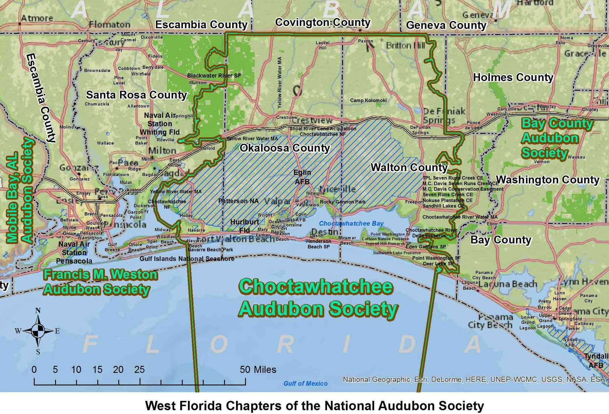
Map of Audubon Chapters (alt text)


       eBird Popular Places and More

For Google Maps, try copying any cell in the "copy this" column to get directions.
Click "directions" to enter two locations. Click + for routing among multiple places.
name copy this owner address lat long eBird
Glenwood Park in Cinco Bayou  
Open from 8 am to 8 pm on any day of the week. A boardwalk follows a stream through a beautiful swamp (forested wetlands) frequented by resident and migratory songbirds. The eBird hotspot pin was placed well within the park. The only entrance is along Opp Blvd NE.
30.4208141, -86.6069811 city 161 Opp Blvd NE, Fort Walton Beach, FL 32548 30.4208141 -86.6069811 eBird page
Okaloosa County Veterans Park 30.3983718, -86.5917277 county 1250 Miracle Strip PKWY SE FWB 30.3983718 -86.5917277 eBird page
Okaloosa Holding Ponds  
This is a Restricted Area on the Eglin Air Force Base Recreation Map. Visitors may be asked to leave by a game warden and perhaps even given a warning or citation. The flat, grassy area between the North and South concrete-lined basins (the two "holding ponds"), which are located 130-730 feet east of Roberts Blvd, are visited by birders any time from 8 am to 5 pm on any day of the week except some holidays. Birders may walk around the two basins but may not walk down into the basins. Please do not enter before 8 am and please leave by 5 pm. The ponds are part of the Arbennie Pritchett Water Reclamation Facility, managed by Okaloosa County and leased from the Eglin Air Force Base. Keep watch for work trucks and park off the paved road (avoiding deep sand). Bobcats, venomous snakes, alligators, bears, wild pigs, and coyotes are seen occasionally, but sand burs, fire ants, and gnats are the most frequent annoyances. Stay away from the buildings and equipment. Be courteous to the facility employees, many of whom wave when driving by. Once in a while, an employee may have a question or even report a sighting. Mr. Arbennie Pritchett began working for Okaloosa County in 1984 and was Lead Operator of the Russell Stephenson Plant. In 1997, he won the Plant of the Year Award from the Florida Department of Environmental Protection. He passed away in 2005.
30.4746, -86.6239 county Arbennie Pritchett WRF and Roberts Blvd north of Wright 30.4746 -86.6239 eBird page
Okaloosa Compost Center  EglinAFB License to OkaloosaCo
Also known as the Wright Landfill or the Okaloosa Landfill. Open weekdays 7am to 330pm, Saturdays 7am to noon. When driving in, stop in front of the weigh station and announce that you are birding
30.4786363, -86.6415739 county N Beal Extension ("Extended" in Google Maps) N of Wright 30.4786363 -86.6415739 eBird page
Henderson Beach State Park 30.385389, -86.4470816 state 17000 Emerald Coast Parkway Destin 30.385389 -86.4470816 eBird page
Vagrant Trail in Okaloosa County  
A part of the Okaloosa Compost Center (aka Wright Landfill or the Okaloosa Landfill). Open weekdays 7am to 330pm, Saturdays 7am to noon. When driving in, stop in front of the weigh station and announce that you are birding
30.4838603, -86.6378886 county North of N Beal Extended N of Wright 30.4838603 -86.6378886 eBird page
Destin west jetty and ponds 30.3859072, -86.5164757 federal US 98 Destin 30.3859072 -86.5164757 eBird page
Gulf Islands National Seashore 30.393237, -86.5924358 federal US 98 and Okaloosa / Santa Rosa Island 30.393237 -86.5924358 eBird page
Harry A. Laird Sr. City Park 30.50156, -86.145919 city Hwy 20 west of Freeport 30.50156 -86.145919 eBird page
Cowford Boat Ramp 30.450949, -85.899337 private Choctawhatchee River crossing W of Ebro 30.450949 -85.899337 eBird page
Rest Stop on I-10 east of Crestview 30.7273665, -86.5077531 federal Roughly 2.7 mi E of Crestview 30.7273665 -86.5077531 eBird page
Blackwater River SF Äì Hurricane Lake NW 30.9407341, -86.7622519 state Beaver Creek RD 30.9407341 -86.7622519 eBird page
Okaloosa Island Boardwalk 30.3950578, -86.5840942 city 1030 Miracle Strip PKWY FWB 30.3950578 -86.5840942 eBird page
Twin Hills Park in Crestview 30.761242, -86.5651095 city Purl Adams AVE and Playground DR Crestview 30.761242 -86.5651095 eBird page
Post'l Point on Eglin AFB 30.4829958, -86.478623 federal Eglin AFB 30.4829958 -86.478623 eBird page
Niceville Spray Fields & Ponds 30.5428215, -86.4483261 city East from 285 near 293 Midbay Connector 30.5428215 -86.4483261 eBird page
Florida Park in Valparaiso 30.4959248, -86.4880416 city Florida Avenue and Bayshore DR Valparaiso 30.4959248 -86.4880416 eBird page
John Beasley Park on Okaloosa Island 30.3934961, -86.583209 city 1550 Miracle Strip PKWY FWB 30.3934961 -86.583209 eBird page
Landing Park in Fort Walton Beach 30.4027636, -86.6069627 city Across from 118 Brooks St SE FWB 30.4027636 -86.6069627 eBird page
Ferry Park Fort in Fort Walton Beach 30.4186093, -86.5980577 city 240 Hughes ST NE FWB 30.4186093 -86.5980577 eBird page
Oak Tree Nature Park in Mary Esther 30.4129284, -86.6668081 city east of Post Office on Hollywood BLVD Mary Esther 30.4129284 -86.6668081 eBird page
Destin east jetty and ponds 30.3823433, -86.5041161 variable Gulf Shore DR Destin 30.3823433 -86.5041161 eBird page
Blackwater River SF Äì Hurricane Lake N 30.9440468, -86.7534971 state Beaver Creek RD 30.9440468 -86.7534971 eBird page
Blackwater River SF Äì Karick Lake 30.8934833, -86.64355 state South Upper North Karick Lake roads from 189 30.8934833 -86.64355 eBird page
Blackwater River SF Äì Hurricane Lake S 30.9383415, -86.7526281 state Kennedy Bridge RD 30.9383415 -86.7526281 eBird page
Liza Jackson Park in Fort Walton Beach 30.4063774, -86.6366708 city 338 Miracle Strip PKWY SW FWB 30.4063774 -86.6366708 eBird page
Gulf Islands National Seashore 30.397531, -86.5814495 federal Choctawhatchee Bay parking lot 30.397531 -86.5814495 eBird page
White Point Park and Maxwell-Gunter RA 30.4560727, -86.4242077 federal 801 White Point Road Niceville 30.4560727 -86.4242077 eBird page
Turkey Creek Park in Niceville 30.5238079, -86.498639 city 340 West John Sims Parkway Niceville 30.5238079 -86.498639 eBird page
Ross Marler Park on Okaloosa Island 30.4002325, -86.5946031 county 1275 Santa Rosa Boulevard Okaloosa Island 30.4002325 -86.5946031 eBird page
Fred Gannon Rocky Bayou State Park 30.5003073, -86.4343357 state 4281 Florida 20 Niceville 30.5003073 -86.4343357 eBird page
Destin Bridge from Okaloosa Island 30.3935, -86.5168 state US 98 Destin 30.3935 -86.5168 eBird page
Mattie M Kelly Park in Destin 30.4115658, -86.4935374 city 825 Beach Dr Destin 30.4115658 -86.4935374 eBird page
Topsail Hill Preserve State Park 30.370076, -86.296728 state 7525 W Scenic Highway 30A Santa Rosa Beach 30.370076 -86.296728 eBird page
Chipley Park / Lake DeFuniak 30.719001, -86.11202 city 1063 Circle DR DeFuniak Springs 30.719001 -86.11202 eBird page
Point Washington State Forest 30.336806, -86.129722 state S County Hwy 395 30.336806 -86.129722 eBird page
Grayton Beach State Park 30.327745, -86.158032 state 357 Main Park RD Santa Rosa Beach 30.327745 -86.158032 eBird page
Lake Jackson - Walton County Park 30.988279, -86.333785 county across lake from Florala State Park 30.988279 -86.333785 eBird page
Cat Island Park - Juniper Lake 30.774141, -86.133378 city 1238 Cat Island RD DeFuniak Springs 30.774141 -86.133378 eBird page
Deer Lake State Park 30.316877, -86.075234 state 6350 E County RD 30-A Santa Rosa Beach 30.316877 -86.075234 eBird page
Eden Gardens State Park 30.37095, -86.11977 state 227 Gilmore RD Santa Rosa Beach 30.37095 -86.11977 eBird page
Tilley Landing 30.53776, -85.895212 state Dead River RD Choctawhatchee River WMA 30.53776 -85.895212 eBird page
Seaside - Public Beach Tower 30.3189218, -86.1384988 beach 2236 E County RD 30-A Santa Rosa Beach 30.3189218 -86.1384988 eBird page
FWB Spray Field (CLOSED SINCE 2011) 30.4689, -86.6352 federal Please do not report sightings to closed spot. 30.4689 -86.6352 eBird page

name copy this owner address lat long links
Coffeen Nature Preserve
Gated - Call before visiting. From the West (Destin), Go east on Hwy 98 to Sandestin Blvd traffic light, watch for a water tower with South Walton written on it. Take the 3rd turning after the water tower. The entrance road has no name but there is a sign ‘Coffeen Nature Preserve’. Take the first right turn after the gate to the office.
30.374136, -86.86.322895 private 146 Coffeen Hill RD, Santa Rosa Beach 850-622-3700 30.374136 -86.322895 Sierra Club Walton Outdoors South Walton
Glendale Nature Preserve
A memorial cemetery with tours open to the public (call 850-859-2141) Thursday to Sunday 9am to 4pm. The Lake Barbara Boardwalk overlooks water where lily pads are in bloom from midsummer through the fall.
30.859758, -86.113204 private 297 Railroad AVE DeFuniak Springs 30.859758 -86.113204 Glendale N.P.
Kellogg Estate 30.403675, -86.214441 private 600-798 E Nursery RD Santa Rosa Beach 30.403675 -86.214441
Morrison Springs Park 30.657332, -85.904764 city 899 Morrison Springs RD Caryville 30.657332 -85.904764
Bruce Creek Landing 30.621442, -85.924809 private 830 Camp House Landing RD Ponce de Leon 30.621442 -85.924809
Hammock Bay 30.478562, -86.091492 private 632-662 Black Creek BLVD Freeport 30.478562 -86.091492
Ferry Trail 30.381562, -86.329779 private 8976 Heron Walk DR Destin 30.381562 -86.329779
E.O. Wilson Biophilia Center 30.476421, -86.053754 private 4956 Florida 20, Freeport, FL 30.476421 -86.053754 E.O. Wilson Biophilia Center
Baytowne Wharf Jolee Island Nature Trails 30.383723, -86.326341 private 8864 Baypine DR Destin 30.383723 -86.326341
South Walton Courthouse Annex 30.374838, -86.180257 county 31 Coastal Centre BLVD Santa Rosa Beach 30.374838 -86.180257
Inland Beach Access 30.274032, -86.005623 beach Walton County west of Camp Helen 30.274032 -86.005623
Okaloosa Island East Beach Access 30.390076, -86.539333 beach Miracle Strip PKWY SE Gulf Islands N Seashore 30.390076 -86.539333 National Park Service (NPS)
Okaloosa Island Middle Beach Access 30.391824, -86.546453 beach Miracle Strip PKWY SE Gulf Islands N Seashore 30.391824 -86.546453 NPS
Okaloosa Island West Beach Access 30.395062, -86.577928 beach Miracle Strip PKWY SE Gulf Islands N Seashore 30.395062 -86.577928 NPS
1st Beach Park Gulf Islands N Seashore 30.394746, -86.603131 beach Blue Dolphin 372 Santa Rosa BLVD FWB 30.394746 -86.603131 NPS
2nd Beach Park Gulf Islands N Seashore 30.395371, -86.607675 beach Emerald View 399 Santa Rosa BLVD FWB 30.395371 -86.607675 NPS
3rd Beach Park Gulf Islands N Seashore 30.396054, -86.612221 beach 530 Santa Rosa BLVD FWB 30.396054 -86.612221 NPS
4th Beach Park Gulf Islands N Seashore 30.396382, -86.616744 beach 600 Santa Rosa BLVD FWB 30.396382 -86.616744 NPS
5th Beach Park Gulf Islands N Seashore 30.396544, -86.621378 beach 700 Santa Rosa BLVD FWB 30.396544 -86.621378 NPS
6th Beach Park Gulf Islands N Seashore 30.396599, -86.62614 beach Doris Jordan Freeway 820 Santa Rosa BLVD FWB 30.396599 -86.62614 NPS
7th Beach Park Gulf Islands N Seashore 30.39714, -86.631287 beach Emerald Promenade 900 Santa Rosa BLVD FWB 30.39714 -86.631287 NPS
Norreigo Point 30.388657, -86.487887 private 30 Moreno Point RD Destin 30.388657 -86.487887
James Lee Park and Crab Trap Destin 30.380416, -86.409081 beach 3500 Scenic Highway 98 Destin 30.380416 -86.409081
Four Prong Lake 30.382818, -86.406742 private 4634-4708 Scenic Highway 98 Destin 30.382818 -86.406742
B-70 Restricted Area 30.517833, -86.772265 federal Eglin AFB 30.517833 -86.772265
Indigo Pond 30.697269, -86.330752 federal Eglin AFB 30.697269 -86.330752
Anderson Pond 30.559009, -86.513214 federal Eglin AFB 30.559009 -86.513214
Rattlesnake Bluff Rd 30.681745, -86.601126 federal Eglin AFB 30.681745 -86.601126
Robert's Pond/253 30.494108, -86.720006 federal Eglin AFB 30.494108 -86.720006
Destin Commons Area 30.393033, -86.423095 private 4000 Legendary DR Destin 30.393033 -86.423095
Bluewater Bay Marina 30.495103, -86.446504 private 1 Marina Cove DR Niceville 30.495103 -86.446504
Glen Argyle Park 30.504698, -86.492315 city Bay ST Valparaiso 30.504698 -86.492315
Kelly Plantation Dr Marsh 30.39905, -86.415442 private 408 Kelly Plantation DR Destin 30.39905 -86.415442
Jesse Rogers Memorial Cemetery 30.408436, -86.659841 city 231 E Miracle Strip PKWY Mary Esther 30.408436 -86.659841 YouTube video slideshow
Memorial Lake Choctawhatchee Bay 30.456572, -86.528925 federal Eglin AFB at Lower Memorial Lake 30.456572 -86.528925
Holding Ponds Fields W of Airport 30.491044, -86.562442 federal Eglin PKWY x Gen Robert W Bond PKWY 30.491044 -86.562442
Twin Cities Park 30.518615, -86.498036 city 170 N John Sims PKWY Valparaiso 30.518615 -86.498036
Boggy Bayou bay in Niceville 30.522278, -86.49958 city 608-638 W John Sims PKWY Niceville 30.522278 -86.49958
Slough by Dairy Queen in Niceville 30.521112, -86.487908 city 297 E John Sims PKWY Niceville 30.521112 -86.487908
Bob Sikes Airport near Crestview 30.786161, -86.525899 city 5551 John Givens RD Crestview 30.786161 -86.525899
Okaloosa Island Fishing Pier 30.393644, -86.592829 beach 300 Pier RD FWB 30.393644 -86.592829
Newman C. Brackin Wayside Park 30.393681, -86.59171 city 1300 Miracle Strip PKWY FWB 30.393681 -86.59171
Don and Susan Stillwell Park 30.443961, -86.609372 county 710 Essex RD FWB 30.443961 -86.609372
Twin Oaks Park 30.52175, -86.500968 city 601-654-680 W John Sims PKWY Niceville 30.52175 -86.500968
Turkey Creek Walk North 30.531809, -86.503384 city 470 W College BLVD Valparaiso 30.531809 -86.503384 Valparaiso Parks
TJ Brooks Park and Pond 30.508142, -86.500153 city Echo DR Valparaiso 30.508142 -86.500153 Valparaiso Parks
Valparaiso Fishing Pier 30.50191, -86.489398 city South of 1157 N Bayshore DR Valparaiso 30.50191 -86.489398 Valparaiso Parks
Mary Esther City Pier 30.406774, -86.650512 city 28 Misty Water LN Mary Esther 30.406774 -86.650512
Main St Park 30.405942, -86.482895 city 605 Main ST Destin 30.405942 -86.482895
Kelly St Bridge 30.402392, -86.488873 city 708 Kelley ST Destin 30.402392 -86.488873
Lions Park 30.510649, -86.480896 city 911 Bayshore DR Niceville 30.510649 -86.480896
Lincoln / Robert E Lee Park 30.508452, -86.488258 city 1231 N Bayshore DD Valparaiso 30.508452 -86.488258
Kell Aire Park North 30.402071, -86.481626 city 810 Kell Aire CT Destin 30.402071 -86.481626
Kell Aire Nature Walk 30.398445, -86.478213 city 874 Kell Aire DD Destin 30.398445 -86.478213
Joe Äôs Bayou Recreation Area 30.412135, -86.4933 city 850 Beach DD Destin 30.412135 -86.4933
Gleanwood Park 30.421467, -86.607736 city Opp Blvd NE Cinco Bayou 30.421467 -86.607736
Garniers Beach Park 30.429928, -86.600404 city 257a Beachview Drive NE FWB 30.429928 -86.600404
Fort Walton Beach Landing 30.402484, -86.60708 city 139 Brooks ST SE FWB 30.402484 -86.60708
Ferry Park 30.418407, -86.59702 city 240 Hughes ST NE Fort Walton Beach 30.418407 -86.59702
Clement E. Taylor Park 30.399631, -86.511333 city 131 Calhoun AVE Destin 30.399631 -86.511333
Meigs Park and Lake Vivian 30.433405, -86.574826 city 45 Meigs DR Shalimar 30.433405 -86.574826
Azalea Park 30.410112, -86.65159 city 9 Azalea DR Mary Esther 30.410112 -86.65159
Longwood Park and Poquito Bayou 30.455581, -86.587295 city 2 or 4 Bay ST Shalimar 30.455581 -86.587295
Bone Creek Recreation Area 30.735918, -86.731852 state Blackwater River State Forest 30.735918 -86.731852
Ellis Rd. Landing on Yellow River 30.748339, -86.625357 county mouth of Trammel Creek 30.748339 -86.625357
Bryant Bridge Boat Ramp 30.724158, -86.793024 county Bryant Bridge RD Holt 30.724158 -86.793024
Eldredge Park 30.466692, -86.600758 county 331 Eldredge RD FWB 30.466692 -86.600758
Wilderness Landing Park (via Corduroy RD) 30.801552, -86.766547 county 5700 Wilderness Landing RD Baker 30.801552 -86.766547
Cotton Bridge Park 30.834566, -86.734213 county 6301 Hwy 4 W outside Baker 30.834566 -86.734213
Bill Duggan Jr. Shoal River Wayside Park 30.699003, -86.570467 county 4502 Live Oak Church RD Crestview 30.699003 -86.570467
Milligan Park 30.748309, -86.625441 county 5100 Ellis RD Baker 30.748309 -86.625441
Guest Lake Park 30.660507, -86.76492 county 3850 Yellow River Log Lake RD Holt 30.660507 -86.76492
Restaurant Rd Beach Access 30.383818, -86.456718 federal 15000 Emerald Coast PKWY Destin 30.383818 -86.456718
Pine Log State Forest
Located in Bay and Washington Counties>
30.423032, -85.880685 state 5583 Longleaf RD Ebro 30.423032 -85.880685


See also the Florida Birding Map of more great places compiled by Elliot Schunke.